Thursday, October 21, 2010

Day 19 - At Sea

So what would a weary traveler have to say about a day at sea? Well here goes (and probably the most uninformative post on this blog.)
We sailed around Labador but were far out to sea and could just make out the coastline. The day was overcast and turned into rain by evening. We were supposed to have a rough ride but it really wasn't bad at all. The roughest ride was in our run up the St. Lawrence River nearning Quebec when we had currents, tides, wind and rain combining to make the ride rough. Overall the day was uneventful and the rest would be needed for the next couple of days.

Wednesday, October 20, 2010

Day 18 - Sydney and Louisburg Part 3

One last thing about Fort Louisburg. One the grass in this picture is a saw horse made to look like a horse. It was used for punishment of soldiers. They were made to sit on it. Their arms would be tied behind them to their musket. Thirty-six pound cannon balls were attached to each leg. It could pull their hips out of their sockets. This was done for all kinds of infractions.
Back in Sydney on our dock is found the largest fiddle in the world - 60 feet tall. Now that is a fiddle.
That night the sunset was dramatic.
Even the clouds were an interesting color. But, alas, no Northern Lights. Darn.


Day 18 - Fort Louisburg Part 2

The big building at Fort Louisburg was the King's Bastion Barracks. It was where many of soldiers barracked and today is a museum of life in the barracks. This is the altar of Kings Catholic Church with a picture of King Louis IX, who became St. Louis - the patron saint of soldiers. Interestingly this church was to be for the officers and officials, but the common men came to worship here and the church for the "commoner" was never built.
As I stated, all the rooms in the Barracks building have been turned into example rooms. This one is a typical kitchen. Notice the laundry hanging to dry.
This would be a bed room for an officer or official. All the upper class had canopy beds like this one.
Barbara with a soldier (a volunteer dressed as a common French soldier circa 1744.) The only problem here is the gender as "she" would never have been allowed in the French army.
This is an example of a typical French enlisted men's barracks.
This kitchen scene is interesting due to the various sized cups on top. They are actually liquid measure cups so liquids could be measured accurately.
e
This lady is dressed in clothing of the 1744 style and is making lace by hand. It takes 50 bobbins and 1 hour and 15 minutes to make one inch of lace. This was a simple pattern. Some patterns take up to 300 bobbins!
In the home of the local engineer was the first mechanical spit for cooking meat. Imagine a running spit from 1744!

Day 18 - Sydney, NS and Fort Louisburg

Today marked the furthest north we would travel on land on this trip. We actually had to sail southward into Sydney harbor as the harbor is on the north shore of Cape Breton Island. The sailing was rough during the night, but the day dawned clear and cool. We really didn't see much of the community of Sydney. We docked in a residential neighborhood, though it was only a couple of blocks from the commercial hub of the city. For shopping they had plenty of shops in the wharf shopping center, along with internet - yes, the first internet I had seen all week. I only had about an hour and a half to work but I at least cleaned out my inbox.
We had booked a tour to the fortress of Louisburg - the crown jewel of the French military fortressess on the North American Continent - now the crown jewel of the Canadian Historical Preservation group. The fort and community have be totally rebuilt from drawings and plans sent back to France when the community and fort were initially built in the 1740s. From across the bay this is what it looks like today.
As I stated previously the whole community surrounding the fort has been restored to the 1744 era. Since the official tourist season was over only some of the buildings were open for us to visit. In the summer they have upwards of 400 people in period costume here manning interactive displays. The fort, in its heyday, housed up to 7,000 soldiers and is gigantic.
Over the retaining wall, where merchant boats would dock to unload goods, you can see the present day community of Louisburg. Off to the left about a mile or mile and a half down the shore line was a battery of cannons along with another battery to the right (0ut of sight) that provided the typical 3 direction fire power to protect the fort. Unfortunately the French lost this fort twice to the British-- both times because they were convinced that they would be attacked from this direction by boat. Unfortunately, the British both times landed on the back side of the peninsula and marched through the forest to the battery at the left (which the French abandoned leaving cannon, cannon balls, and powder) so the British could bombard Louisburg with its own defensive weapons. The first time that the British overtook the fort the French were allowed to leave with all weapons, etc. and given safe passage off Cape Breton. After the French reestablished themselves here a few years later and the British had to again recapture the fort, they imprisoned all the captives, took them away, and destroyed the fort. In the 1960s Canada realized the tourist value of the fort and began the restoration process which continues to this day.
French soldiers were often kidnapped and pressed into service. Most of them were illiterate so they would need non-verbal ways to know where certain things were located - like the local pub. This sign was designed for them to know this is where they could get some liquid refreshment and the sun was to remind them they needed to be back to the barracks before dawn.
The streets of the community were fairly wide. Only officials, military leaders, etc. were allowed to walk in the center of the street. Commoners and regular soldiers were required to walk along the sides of the streets. Why? No plumbing-- so human and laundry wastes were collected in pots and just thrown out the windows onto the streets. The wealthy didn't want to get all dirty and smelly when traveling through the town so they walked down the middle!
This is the restoration of the Frederick Gate where all merchants would enter the community. The local governor caught flack for build this extravagant structure.
There was no running water and all water had to be gathered from wells like this one. Disease was endemic and sanitation was the biggest cause of their health problems.
Canada has gone so far as to reintroduce animals, like these sheep, which are the same breeds as would have been found here in 1744. Remember this place had to be as self-sufficient as possible. So vegetable gardens abounded, and domestic animals were found here in abundance.

Tuesday, October 19, 2010

Day 17 - Halifax, NS Part 3


Our last stop was the Halifax Maritime Museum. One of the interesting things it has is a large collection of realia relating to the Titanic as this is the closest port to the sunken ship. Most of the victims were sent here after the ship sank. This is a model of the Titanic.
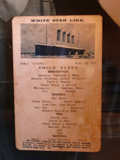
Here is an actual menu for third class (poorest) passengers. The menu for second and third class passengers were much, much better.
This was part of the woodwork inside the Titanic that was picked up after the ship sank. Rescuers collected anything that floated to the surface - not just bodies but any pieces of the ship that they could find.
These shoes belonged to a child that they never could identify until this year when DNA allowed them to figure out who he was. He wasn't claimed as all his family died in the sinking of the Titanic.
Some people took the pieces of wood that they collected in the ocean and turned them into all kinds of items - here a rolling pin and a plate among other things.
How dangerous are these waters? Each red dot on this map represents a sunken ship or boat. These are unforgiving waters. Overall this was a very interesting day.

Day 17 - Halifax, NS Part 2

If we wanted to reduce our trip to three words it could be "trees, lighthouses, and forts." Those were the three constants of the trip. Our next stop was the Citadel atop a hill in the middle of Halifax. Of course this picture isn't it - this is one of the two companion forts built to defend the whole harbor. Another fort was across the bay.

Though it was initially built in the 1700's it was never captured by enemy armies. If you build a fort correctly, in a perfectly defensible position, it should be successful and this one was. This was the inner wall of the fort - using natural defense (earth) the walls were up to 25 feet thick. The big cannon ringed the fort and living quarters were under the guns built into the wall.This was our guide dressed in enlisted soldier clothes. He is actually a volunteer for the local preservation society.
This volunteer is dressed as a British officer as they would have been dressed during the Revolutionary War.
The inner walls were surrounded by another, even bigger, outer wall. With the dual walls, and being in a star shape, any attackers would have a terrible time actually defeating this fort. Any attackers who could get down in between the walls would face rifle fire and cannon shots from three directions. The narrow slits are rifle locations and the rectangles are where cannons would be placed.
How do you get messages out? Indians use signal fires, but the British used flags. The shorter pole was for messages to the other forts and the taller one was for hanging of the flags of the ships coming in or those in port. It would fly company flags of commercial ships. The flags of navies could also be flown here so everyone would know who was in port.
Oops - here is a mess up. This artwork is called "Fishermen's Monument" by William DeGarthe out at Peggy's Cove. Somehow I forgot to put this in the last post. It took this man years to carve the granite memorial.


Day 17 - Halifax, Nova Scotia Part 1

OK - this really fits in with the day before, but we will put it here. After dinner (the night before) Barbara had an extreme attack of esophageal spasms, and we ended up in the ship's infirmary. To get an idea of the pain, she said she wanted to rip off her clothes and jump overboard! It was bad!!! After a careful evaluation of her, and an EKG, she was allowed back to our stateroom. I don't know if the smile is because she feels better or she was happy the bill was as small as it was.
Halifax is a bustling modern city in Nova Scotia (New Scotland for all the people who escaped Scotland and moved here.). We had another beautiful day. We were extremely lucky that the weather was on our side almost every day.
No tours in Halifax for us. On our trip to Alaska, we met a mother and daughter (Pauline White and Cindy Patriquin) and have kept up our friendship. They were gracious in offering to chauffeur us around for the day. It was a delightful day. They also were willing to take us into Dartmouth to see some old friends from Fresno (Elder Michael and Sister Lois Tanner) who are missionaries for the Church and run the office for the Halifax Canada Mission of the Church. This mission covers Nova Scotia, New Brunswick, Newfoundland, Prince Edward Island, Labrador and a little of Maine. This is an immense area in size - about as big as the United States. It was fun to see them, since they left Fresno several years ago for Utah, and are now here in Nova Scotia.
Our first tourist stop was Peggy's Cove - the place all tourists have on their list when traveling to Halifax. It is about a 45 minute drive from town, and, of course, has the classic lighthouse. This one is exceptionally photogenic. being out on a rocky point. When storms come through, the breaking waves can literally break up on land up to the lighthouse. I loved this on a sign on the lighthouse:
Warning
Injury and death have rewarded careless sight-seers here.
The ocean and rocks are treacherous, so savor the sea from a distance
We were greeted by the sounds of music coming from a bagpiper. We found her down by the lighthouse. She is a struggling college student, playing music for donations. This was so appropriate out here at Peggy's Cove.
Cindy, Pauline, Barb and I next to the lighthouse. This is from the ocean side of the lighthouse.
Peggy's Cove hugs the coastline in a tundra environment. Because this area is washed over by waves on a regular basis, there are few plants here, though a couple of miles away it is forest land. The salt in the sea must kill off most of the natural vegetation.
Here is another shot of this picturesque little village. The nice thing of being on our own was that we could wait for all the tourist boats to leave and have the village almost to ourselves. We ate lunch here without a ton of people all over the place.